The Master Plan
In 2017, the Market Town team participated in the work on the Urban Development Act. This was done because it was clear it would take decades and cost millions to complete a project under a council district plan. It then took three years for the Act to become law, and just as it did Covid shut down the nation.
The steps
- Begin with the prototype master plan
- Refine the plan to become the final prototype
- Establish a Benefit Company as developer
- Find land that best fits the prototype plan
- Adapt the plan to fit the land
- Finance the project
- Begin implementation
- On-site pop-up factory makes the buildings
- Urban core divided into 20 “villages”
- Future villagers participate in charette planning
- Financing packages mortgages into securities
- Build the motorpool and freight depot
- Solar array and vanadium battery storage
- Rainwater harvesting and storage
- Wastewater processed as surplus resource
- Zero waste recycling plant
- Factory makes 20 town houses per day
- All villagers move in in the same timeframe
- When done, B-Corp becomes operating company
Plan before Land
The prototype plan
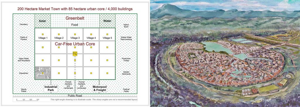
A prototype plan is similar to the rules in an operative district plan. Indeed the market town prototype plan was adapted from the Queenstown Lakes District Plan for the village at Jacks Point. As a prototype, it would fit a generic 200 hectare parcel of flat land with no complications. No protected species, no water or wetland issues, no historic presence, just a flat open paddock of low-quality rural land (not prime ag land)
Plan Before Land: By refining this prototype plan, 85% of the work one would encounter in a public or private plan change for a specific area of land is completed as a desktop effort before the land search. This not only saves time, but points the land search in the right direction. A conventional developer buys land, then endures a gauntlet of challenges trying to demonstrate how the complications can be mitigated or avoided. By reversing the process, the land search looks for the least complicated land, thus avoiding many consenting obstacles.
WYSIWYG: The actual site will determine the final plan, but unlike a generic district plan that contains variables, the final site plan change will be prescriptive – what you see is what you get. It will set out the precise boundaries, the line between the greenbelt and the urban core, the pedestrian streets and the location of every building.
Public Support: The prototype plan was developed to avoid the legitimate concerns of the site’s neighbours. When one proposes to put a 10,000 population development in a rural area, the neighbours can be expected to be alarmed. They fear noise, lights, traffic congestion and suburban creep, among other concerns.
Greenbelt: The urban core works on about 85 hectares, but the plan calls for 200, with over 55% of the land as a surrounding greenbelt so all the neighbours will see is a belt of trees. No lights, no noise, no urban activity. Further, the greenbelt will contain its own solar array, rainwater harvesting and wastewater treatment plant so there will be no digging up the access roads for utility services.
Low Traffic: The town economy is intentionally designed to have no outbound commuters, and to discourage inbound workers. Instead of courier vans, it will have a freight depot with say three tractor trailer trucks that make all package, supply and mail deliveries. All day-to-day destinations will be within the urban core, thus there will be no road congestion on the rural roads. Because the urban core is car-free, all resident and visitor vehicles park in the greenbelt’s motor pool.
Food Contracts: It is recommended the town contract with the surrounding farmers for long-term food supply and in some cases may purchase surrounding farms to ensure no suburban sprawl. The town operates its own local economy which becomes an economic engine for the region.